
EXPRESSWAY THEN - PUBLIC TRANSPORTATION NOW:
A debt owed to the people who lived there then and who are living now
in and around the Franklin-Mulberry Gash in West Baltimore
[updated through March 17, 2011]
"RESTITUTE - 1: to restore to
a former state or position; 2: give back"
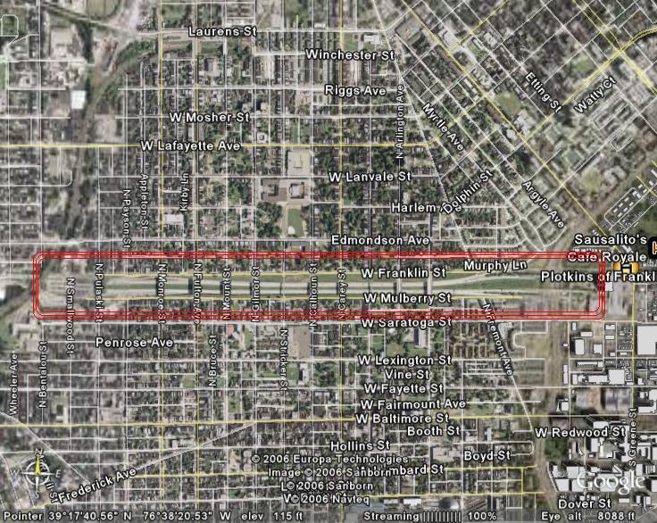
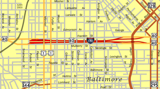
More than 40 years ago, the Baltimore City Council decided to condemn almost 1,000 properties located on Franklin and Mulberry Streets in West Baltimore. Thousands of tons of paving and dirt and the wreckage of houses were removed, leaving behind a one-mile long trench or ditch - better called a gash for what it did to the surrounding neighborhoods and communities. This was all to make way for the fabled (and later failed) East-West Expressway, which was to run across the center of the City from West and Southwest to the Southeast. Due to effective community outcry and opposition, most (2/3) of the planned 23 miles of expressway never were built. But, twenty years of expressway planning left a negative legacy for the people of West Baltimore: It severed many of their neighborhoods and destroyed many of their communities. That destruction, for the most part, remains there today - in 2011.
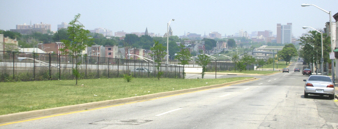
This part of West Baltimore had many lively and healthy communities before the mid-1960's. Today, many of those communities are shadows of their former selves. In the wake of the planned expressway, most of the businesses left - both commercial and industrial. Thousands of people, both homeowners and renters, fled the area, relocating to Southwest Baltimore and north to the Park Heights area. After all this displacement, the expressway was not even built through the so-called Franklin-Mulberry Corridor, except in the form of an isolated part of a freeway, Interstate 170, the "road to and from nowhere in particular," which was built into the gash. This little job cost $50 million of taxpayers' money. It now represents an obsolete auto-oriented urban concept stuck in the middle of communities with relatively few cars.
Today, in too much of this part of West Baltimore, there are boarded-up houses,unemployment, drugs, crime, and human misery. It is both ironic and troubling that such community destruction did not take place nearly to the same degree on the Southeast side of town down by the Bay. Look over there today and see the vast and high-priced economic development projects which were built where the expressway was supposed to go!
But - all this can be changed. There is a debt owed to the people of West Baltimore which the City needs to pay. Only through such payment will the deserved healing and restitution come to pass. And this payment should come in the form of renewed development and a renewed sense of community in the areas located in and around the Franklin-Mulberry Gash. This development must be led by and on behalf of the people of West Baltimore. For this enterprise, the people need to be in the driver's seat - doing the planning, helping with the design, and obtaining jobs and other benefits from what is proposed and built. This will not replace what has been lost, but it may provide some kind of compensation for the wrongs which were done and, in that way, represent some measure of social justice for the people of West Baltimore.
Expressway then and Public Transportation now - these stories can be related. The East-West Expressway is not simply some old, long-forgotten failed highway project from two generations ago. No - the expressway project is still very alive today in the minds of the people of West Baltimore. It is what caused this debt to them, and now it is time to do, in the right ways, the right kind of transportation planning, construction, and operation. There is a direct link to be made, timeline to be drawn, between the failed East-West Expressway and Baltimore's public transportation hopes and plans for the 21st Century. Since both the City and the State were involved 40 years ago with the expressway, the new plans for the Red Line to put high speed transit through this area of West Baltimore provides both both City and State with a special opportunity to begin this healing and restitution for the people of West Baltimore. This new transportation line offer the chance to develop the areas around it which are impacted by it or which have station stops located there, through so-called "transit-oriented development" (TOD, for short). This development could also include jobs for people living in these areas. There has already been one proposal from some persons living in the area - to completely cover over the gash. The idea would then be to use the area under the cover as a tunnel for the Red Line, and to use the area on top of the cover for ambitious commercial and other development for the communities located in the area.
The time to begin to repay this debt, to restitute, is now!

In October 2006, at the Lockerman Bundy Elementary School on N. Pulaski Street
in West Baltimore, an extensive community workshop was held, sponsored by the Maryland Department of Transportation and focusing on the community and commercial areas around the nearby
West Baltimore MARC station (and the Red Line which is currently being planned for transit in and through the area). A preliminary meeting was held on October 3rd. This was followed on
October 14th by an all-day Kick-Off meeting, beginning what was called a "charrette" process. Following this, from October 16th through the 19th, the community was invited to drop in informally
during the day, and attend a night session to hear a presentation by a team of planners, architects, urban designers, and an economic
development specialist, among others. A significant number of community members showed up on the last night of the Charrette, Thursday, October 19, to communicate that they were
dismayed at having not been part of the process up to then. In short, many of those present were not ready or willing to hear the planning team's message. Therefore, the team decided to pull back, and
permit and encourage individuals, neighborhoods, and community associations to meet on their own for the indefinite future - until they felt more ready to hear the team's message.
Beginning in November and into 2007, a group of community associations and individuals residing in West Baltimore along with a few representatives of interested
advocacy organizations, met monthly first in a church activity room and then in a community center near the intersection of Pulaski Street and Edmondson Avenue.
By January 2007, the group had decided to call itself the "West Baltimore Coalition." By mid-March, the Coalition was ready to hear the message from the planning
team. In the interim from the October Charrette to March, the team had worked to refine its presentation.
POPULATION HISTORY OF WEST BALTIMORE: As a follow-up to the October 2006 charrette, on Friday and Saturday, October 12 and 13, 2007, the communities in West Baltimore,
along with City and State government representatives and technical advisors, held the "West Baltimore MARC Station Transit-Centered Community Development Workshop."
The first night was devoted to presentations, and Art Cohen, Convenor of b'more mobile, was asked to give a presentation on West Baltimore's Past for the part of West Baltimore closest to the
so-called "Highway to Nowhere" or the Franklin-Mulberry Gash. This was done using official US Census data from 1940 to 2000. Because of several requests for information from that
presentation, a slightly-revised version of it in PDF form is now included on this website. Although these slides do not contain the oral commentary which accompanied them, it is
hoped that most of the slides will speak for themselves.
 To return to the Home Page.